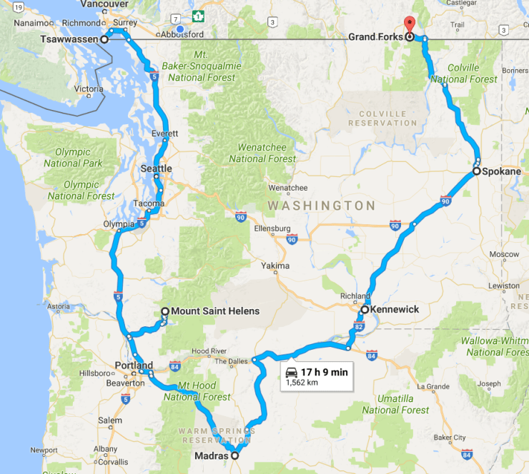
To reach our chosen spot to watch the eclipse (Madras, in central-west Oregon) we took a road trip over a few days, from Vancouver and back to Grand Forks in British Columbia. Our outbound and return legs took us west and east of the Cascade mountains respectively, which offered some interesting insights into the different styles of volcanism that have shaped the landscape of the Pacific North West. In particular, it was striking to see the contrast between the much more recent volcanic activity at Mt St Helens and the ancient but vast deposits of the Columbia River Flood Basalts. While these are well studied and documented geological formations, I felt it would be interesting to write up some of these observations.
Mt St Helens
Even non-scientists will be familiar with Mt St Helens. An active stratovolcano, close to population centres in the US, was always likely to attract attention, but the hugely dramatic eruption in 1980 is well known as a prototypical volcanic disaster. In many ways, though, it was an unusual event; the ash and pyroclastic flows were a product of explosive decompression, after the entire side of the mountain slid away.
The park rangers give a great analogy to describe what happened. Under the volcanic cone, magma was gradually building up – much of it full of volcanic gasses. Imagine a fizzy drink bottle, full of bubbles. The magma pushed its way into the subsurface, and in doing so caused a number of earthquakes. The largest of these, just prior to the main eruption, caused the entire side of the mountain, made of relatively loose material, to collapse as a giant landslide. This acted to hugely reduce the pressure on the magma inside the volcano, still full of gas; imagine that now the fizzy drink bottle has had its lid removed, having been shaken up. You can imagine the resulting eruption!
This kind of collapsing mountainside-triggered event was unusual though; Mt St Helens was the first well-documented example. The resulting blast levelled trees all across the landscape; even today, these either lie where they fell or have been washed en masse into the nearby lakes.

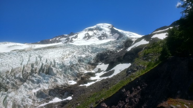
The mountain itself is still stunning, albeit without the symmetric character that led to it being dubbed ‘Mt Fuji of the Americas’ before the eruption. The giant crater and the smaller incipient ridges within it (produced since the eruption as magma pushes upwards into the crater) is a formidable sight. In the early Victorian period, rugged mountain ranges were often viewed as terrible, forbidding scenes, a perspective that contrasts with the more modern view of mountains as sites of awe and beauty. Mt St Helens manages to bridge that divide – at least for me. The impressive nature of the topography cannot be disentangled from the very human side of eruptive history, in which dozens perished.

Personal bias as a result of my own previous study of landslides ensured that I spent a fair while considering the debris avalanche and the deposit that remains. In the image above, the whole foreground is dominated by the deposit, which is still the largest debris landslide in recorded history. The ‘hummocky’, or lumpy landscape results from great chunks of mountain that slid downhill overlain by finer, loose deposits on top.
A couple of interesting aspects, from my perspective. First, the snow melt and flooding is clearly cutting quickly into the loose deposits every year; those canyons that can be seen in the centre of the image are being incised at high speed (I estimate on the order of metres per year). This could be a great set of field observations for sediment scientists, if it hasn’t already been studied!
Secondly, those familiar with my PhD work will know I looked at the way in which landslides can affect the amount of dissolved mineral elements in the water draining across and through their deposits. As such, seeing the largest landslide on record certainly piqued my interest as to the state of the water chemistry in the Toutle River, which drains the bulk of the deposit. It would be a cool test of concept if a time series exists! If anyone is aware of such a data series, please do let me know.
Mt St Helens is only one of the sporadically active Cascade volcanoes. Their form is in many ways similar; they stand proudly above the surrounding landscape by several thousands of feet, formed as individual cones. We saw a number of these (Mts Jefferson & Hood were visible from the vantage point where we watched the eclipse), and last month I climbed Mt Baker, the northernmost large volcano.
The landscape over which these volcanoes tower bears the marks of another type of volcanic eruption; perhaps less obvious, but only because the hallmarks are thousands of kilometres from edge to edge.
Columbia River Flood Basalts
Volcanoes like the Cascade examples form as magma rises at the margin of colliding tectonic plates; many may have heard of the ‘Pacific Ring of Fire’, and these volcanoes are part of that system. This isn’t the only way in which volcanoes can form though. In some places, hot material can well up from many thousands of km deep within the Earth’s mantle, and as it nears the surface, begins to melt due to the elevated temperature. This molten magma then erupts through the plate above – as a ‘hot spot’. This is the kind of volcanism we see today in places such as Hawaii.
These kind of eruptions are generally less explosive than those at plate boundaries, but can also produce vast quantities of lava; and that’s exactly what scientists believe happened in Washington and Oregon some 14-17 million years ago. The huge quantity of lava that was erupted eventually inundated the landscape, in some cases to over a km in depth, over nearly 200,000 square kilometres.
And so, as we drove across this landscape, we saw outcrops of this lava exposed literally everywhere. The lava cooled into basalt, and as it did it cracked in very distinct ways – forming ‘columnar joints’, much like the famous Devil’s Causeway in Northern Ireland.

The landscape created by these vast eruptions is primarily a flat one, but rivers have incised deep gorges into the lava flows in many places, such as seen here near Warm Springs, Oregon:

We drove for nearly a thousand kilometres through and on top of these lava flows, and that more than anything else gave the best sense of the size of these eruptions. The columns of basalt, which for a while seem monotonous in colour and form, eventually become more and more astonishing as it becomes clear that this is among the largest volcanic structures on the planet. The volcanoes to the west are suddenly shrunk in the mind’s eye, even when the tallest (Mt Rainier) is over 4km above sea level.
